Names of the Gorge
Names of the Gorge
Crossing the Severn
Open the interactive river map of fords, ferries and bridges.
Before there was an Ironbridge, before Coalport’s wharf or the clatter of Jackfield’s tile works, the map of this part of Shropshire looked very different. In the Middle Ages it lay inside a huge administrative block called Bradford Hundred, later divided into North and South. The parishes of Madeley, Buildwas, Benthall, and Broseley all sat inside the southern division.
A hundred was an Anglo-Saxon invention — an area that could raise a hundred fighting men or roughly a hundred households. By the 1100s it worked like an early council, fixing taxes and disputes. These boundaries mattered less for where people lived, more for who paid what.
From those large medieval parishes grew the patchwork of names we still know — some villages, some hamlets, and some just a handful of cottages clustered around a pit, a wharf, or a ferry.
Madeley was the mother parish on the north side of the river, stretching from Coalbrookdale through Jackfield and down to Coalport. Across the Severn lay Broseley parish, which included Benthall Edge and the Benthall estate — the two parishes facing each other across the Gorge, their mines, ferries, and families tied together by trade.
Smaller hamlets — Lloyds, Lincoln Hill, Ladywood, Gitchfield, Sutton Hill, Jiggers Bank, Calcutts, Willey — appeared in tithe maps and parish rolls as workmen’s rows, ferries, and scattered cottages, each named for its craft, its landowner, or the lay of the ground.
By the time the first printed county maps appeared in the late 1500s, those names were already taking root — Saxon clearings and medieval farms that would one day stand beneath smoke and iron.
The Maps that Froze Time
In 1574, Queen Elizabeth I’s official Thomas Seckford commissioned surveyor Christopher Saxton to map every English and Welsh county — the first national atlas of its kind. By 1577, Saxton’s engraved maps were finished, and in 1592, Lord Burghley declared that every Secretary of State should own a copy.
This was how government learned the shape of England.
Saxton’s Shropshire is a world before industry — no Ironbridge, no canals, not even a single road.
The county boundary is marked by dotted lines; neighbouring counties are named but left blank.
Hills are sketched as little brown humps, shading to the east; rivers double-lined and inked blue.
Market towns are drawn with clustered houses, villages with a church tower. Castles, windmills, bridges, deer parks, and forests all get their own tiny symbol. It’s beautiful but basic — power mapped through land, not people.
Through the 1600s and 1700s, other mapmakers added polish and pride.
John Speed (1610) reworked Saxton’s survey, giving Shropshire a decorative cartouche, coats of arms, and a town plan of Shrewsbury.
Joan Blaeu (1665) hand-coloured the county for his grand Atlas Maior, where cherubs hold up the scroll and Latin text frames the Severn like a ribbon.
Bassett & Chiswell (1676) reissued Speed’s design for an English audience, with tidier lettering and more legible towns.
Then the maps start to hum with industry.
John Cary (1805) added canals, roads, and hachured hills — neat, precise, and modern.
Christopher and John Greenwood (1830) took it further, surveying the county yard by yard and engraving even the tramways and rope-walks.
By the Ordnance Survey of 1862, the Gorge is packed with detail: pits, furnaces, cottages, limekilns, rope-walks, and pubs — every inch of the valley measured and named.
In three centuries the Severn valley had gone from an anonymous green sweep on Saxton’s parchment to the most documented industrial landscape in England.
Madeley — the Mother Parish
If you want to find the root of every name in the Gorge, start here. Madeley is the trunk of the tree — everything else branches from it.
The first record comes from the Domesday Book of 1086, where it’s written Maddelege: fourteen households, a priest, and woodland for swine. The name means “Madda’s lēah” — lēah being Old English for a clearing, meadow, or patch of cultivated land in the woods. In other words, it was Madda’s clearing, carved out of forest on the northern bank of the Severn.
Historically, Madeley parish stretched from the uplands above Coalbrookdale right down to the river, taking in what later became Madeley Wood, Jackfield, and Coalport — all hamlets within its ancient boundary.
Jackfield is listed under Madeley in the 1849 Tithe Award, recorded as such by the English Place-Name Society, and shown inside the parish line on nineteenth-century Ordnance Survey maps.
For centuries, Madeley parish covered everything from the uplands above Coalbrookdale down through Madeley Wood, Jackfield, and Coalport. Its land stretched to the river and beyond the Iron Bridge site long before the bridge itself existed. In medieval terms it was enormous — farms, quarries, small forges, and woods all managed under one ecclesiastical parish.
By the 1600s, enclosure and industry had started nibbling at its edges. EPNS notes that by 1660, the “Madeley woods” were no longer common ground but fenced, mined, and worked. The name “wood” hung on even after the trees disappeared, a polite fiction for a landscape of pits and spoil.
Then the industrial age erupted. In the 1700s and 1800s, Madeley’s parish rolls start listing ironworks, rope walks, brickyards, and tramways.
By the 1849 Tithe Award, the streets we still know — Court Street, Park Lane, Rope Walk, Wharfage, and Victoria Road (once Shooting Butts Lane) — appear as property entries. The transition from forest to furnace was complete.
It wasn’t just mines and works that filled the parish — it was people, and people meant pubs. The 1849 Tithe Award and later directories list over two dozen of them, enough to quench every corner of the parish.
Madeley’s Public Houses (1849 and later records):
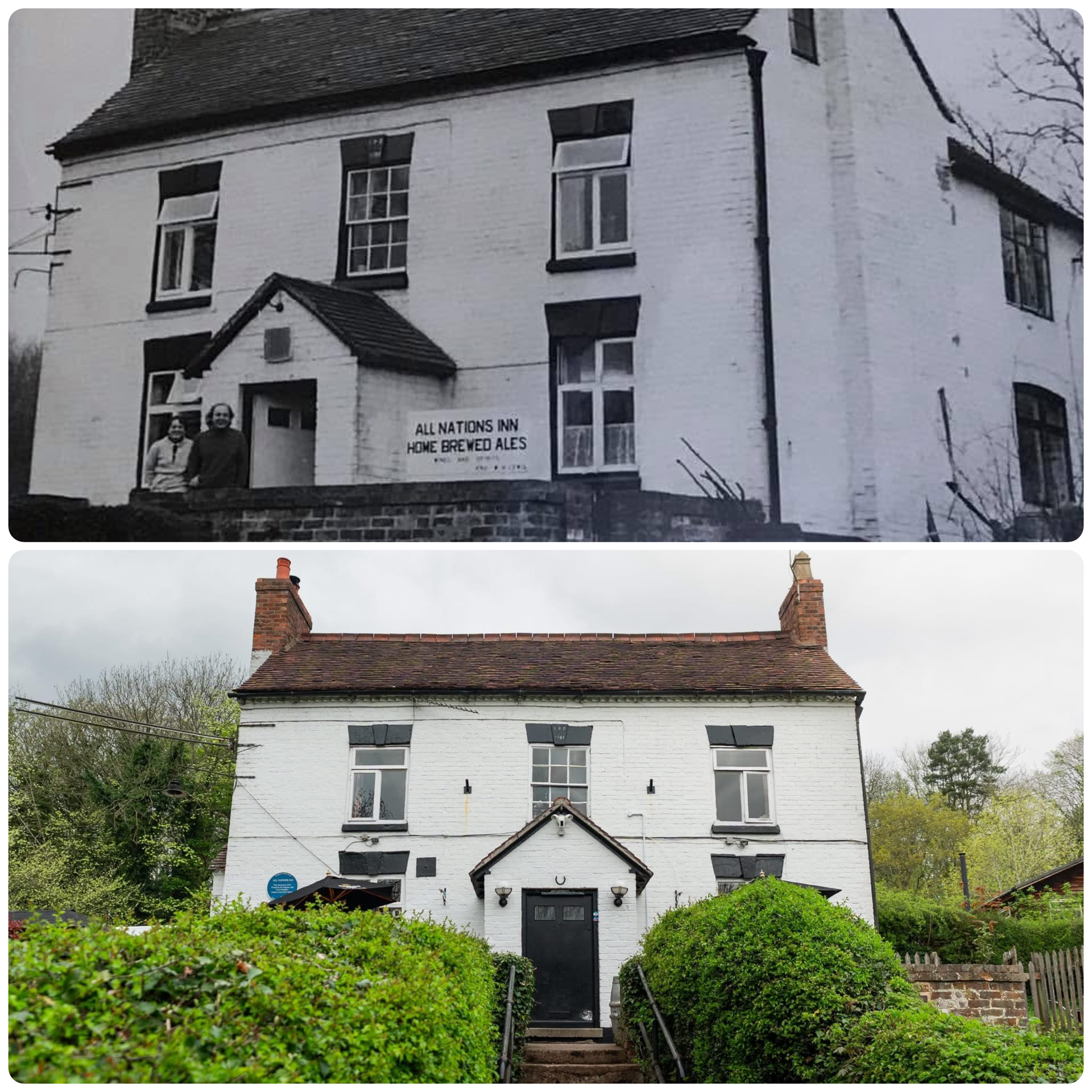
All Nations, Bath Tavern, Bird in Hand, Blockhouse, Brewery, Chestnuts, Coopers Arms, Crown Inn, George & Dragon, Golden Balls (sic), Half Moon, Horse and Jockey, Horse Shoe Inn, Pheasant, Queen’s Head, Robin Hood, Rodney Inn, Royal Oak Inn, Six Bells, Swan Inn, Three Tuns, Tontine Hotel, Unicorn, Wheatsheaf, White Hart Inn, and White Horse Inn.
Every few hundred yards was another signboard, another doorway glowing with lamplight. Half the valley’s life happened over a pint.
The parish church of St Michael’s, rebuilt in 1796, watched over it all from the hilltop — from Saxon clearing to smoke-streaked skyline.
Coalbrookdale — The Cold Brook
The name Coalbrookdale sounds almost too neat for its history, as if the ironworks had named the place. But the words came long before the furnaces.
The earliest known form is Caldebroc (1250), from the Old English cald brōc, meaning cold brook. The stream that runs down through the valley to the Severn still fits the description — cold and clear where it rises above the gorge.
EPNS confirms that this early name referred simply to the brook and its narrow valley. The “coal” spelling was a happy coincidence: the word changed naturally over centuries of speech, long before coal became the valley’s fortune. Only later did “dale” appear, a late 18th-century addition borrowed from the landscape rather than the records.
For most of the Middle Ages, Coalbrookdale wasn’t a place you’d find on a map at all — it was part of Madeley parish, a wooded side valley feeding the Severn.
1805 – John Cary: the word Coalbrookdale appears in print for the first time on a national atlas — by then the name had caught up with the fame of Abraham Darby’s furnaces.
The riverbank where Darby first smelted iron with coke in 1709 became the heart of a settlement that redefined the world’s relationship with metal. Yet, even then, the old name lingered quietly on parish records — Caldebrok, the cold brook, still trickling beneath the ironworks that borrowed its name.
Coalbrookdale never needed rebranding. The word evolved on its own, from brook to valley, from nature to industry — proof that sometimes the past sets the name long before the future arrives.
Dale End — The Edge of the Valley
“Dale End” sounds ancient, but it’s actually a latecomer — a practical label for the place where the valley of Coalbrookdale flattens out and meets the Severn.
On the early maps — Saxton (1577), Speed (1610), and even Blaeu (1665) — there’s no mention of it at all. The name only begins to appear after the Industrial Revolution, when the bottom of the dale filled with wharves, workshops, and rows of houses.
John Cary’s map of 1805 doesn’t yet mark it, but by Greenwood (1830) the sprawl of buildings at the foot of Coalbrookdale is clear. By the Ordnance Survey of 1862, “Dale End” is printed boldly on the sheet — a label that reflects the geography as much as the growing settlement.
Dale End wasn’t a separate parish or hamlet in its own right, but a descriptive term that locals used long before the cartographers caught up. It marked the transition point — the bottom of Coalbrookdale where the dale literally ends and the riverside wharf begins.
During the 19th century it became a hive of activity: iron foundries, warehouses, small traders, and workers’ cottages packed tightly between the hill and the river. The area bridged two identities — industrial Coalbrookdale behind, mercantile Ironbridge ahead.
By the Victorian period, it was a busy thoroughfare lined with shops and inns. Travellers could step off the road from Shrewsbury, cross the bridge, and find themselves at the very mouth of the dale — the gateway between the hill and the water.
“Dale End” has always been less a village than a geographical moment: the meeting place of brook, bridge, and river. Its name says exactly what it is — the end of the dale, and the start of everything else.
Benthall — The Bent-Grass Nook
Across the Severn from Ironbridge rises Benthall Edge, its limestone cliffs catching the morning sun above the river. Though it feels part of Madeley’s story, Benthall has always belonged to Broseley parish, its identity older than the industries that later hemmed it in.
The earliest spellings — Benetala (12th century), later Benthalle, Bental, and finally Benthall — come from the Old English beonet, meaning bent grass, and halh, a nook of land or small valley. Together they describe a “nook of bent grass” — dry upland ground where wiry meadow grass clings to the thin soil above the Severn’s bend.
Long before the Elizabethan manor, the land gave its name to the people who owned it. Benthall Hall, begun between 1535 and 1580 and rebuilt after the Civil War, still looks across the same sweep of wooded hillside that defined it in medieval records.
By Saxton’s 1577 map, “Bental” already appears as a named site — one of the few in this part of Shropshire. The Edge’s quarries and pits later supplied stone and ironstone to the forges and furnaces below in Coalbrookdale and Madeley Wood. By Greenwood (1830) and the Ordnance Survey (1862), you can trace the parish boundary running down the middle of the Severn, with the hall, edge, and ferry all clearly marked.
Beneath the cliff, at the water’s edge, lay Bowyer’s Yard — a tight row of cottages and workshops squeezed between the rock face and the river. The English Place-Name Society lists it under Benthall parish, likely named after the Bowyer family rather than the trade itself. Records show it occupied through the 18th and 19th centuries, its inhabitants quarrymen, ferrymen, and labourers working both banks.
Later maps sketch out the line of houses just upstream of the ferry landing, where the road pinched between river and edge.
Floods often reached the doorsteps, and several families crossed daily to work in Ironbridge or the wharves of Madeley Wood. Today the cottages are gone, but the name lingers — one of the many small, easily-missed settlements that made up the living spine of the Gorge.
Benthall’s story is one of continuity: its hall, its edge, and its name long predate the ironworks that later gave the valley fame. Beneath the soot, it remains what it always was — a grassy nook above the river, quietly watching history pass below.
Broseley — The Guardian’s Clearing
First recorded in Domesday Book (1086) as Broselie, the name comes from the Old English Burgweard’s lēah — “the clearing of Burgweard,” a personal name meaning town guardian.
Broseley developed early as a manorial centre on the south side of the Severn, its parish including Benthall, Lloyds, Calcutts, and Willey. By the 1600s it was already producing clay pipes, pottery, and iron, supplying labour and materials to the works later established at Coalbrookdale and Madeley Wood.
On Saxton’s 1577 and Speed’s 1610 county maps, Broseley appears as one of the few named settlements in this part of Shropshire.
By the 18th century, collieries and brickworks covered its slopes.
The 19th-century Ordnance Survey marks numerous public houses — The Foresters Arms, The Lion, The Duke of Wellington, The Three Tuns, and The Black Swan among them — reflecting its dense industrial population.
Though later overshadowed by Ironbridge, Broseley remained the administrative and cultural heart of the southern Gorge, its ancient “guardian’s clearing” still visible in the pattern of lanes and old field names.
Jackfield — From Pasture to Port
The name Jackfield first appears in records around 1550 as Jake Fylde, probably meaning “Jack’s field.” Earlier Broseley court rolls from the 1400s mention “Jackes,” suggesting the name came from a landholder or tenant rather than the trade.
Originally it referred to open riverside pasture within Madeley parish, later developed for coal mining, clay extraction, and tile works. The English Place-Name Society notes that by the 18th century “Jackfield” had come to describe the entire industrial settlement along the south bank of the Severn.
By Cary’s 1805 map, the name is clearly marked; by Greenwood’s 1830 survey, it stretches along the river opposite Coalbrookdale.
The 1862 Ordnance Survey shows the village lined with works, cottages, and wharves — a complete industrial riverside.
Jackfield was also known for its ferries and pubs, serving workers crossing the Severn and canal trade.
Notable inns included the Boat Inn, Black Swan, Dog & Duck, and Tumbling Sailor — all recorded in 19th-century directories.
The Tuckies Ferry, run from the Boat Inn, was the main crossing to Coalport until the Jackfield Memorial Footbridge opened in 1922.
Though industrial decline hit hard in the 20th century, Jackfield’s name — like its tiles — travelled far beyond the Gorge. Today it marks a place still defined by the river: once a field, then a port, now a survivor.
Coalport and Preen’s Eddy — From Eddy to Port
Before there was a Coalport, this bend in the Severn was known as Preen’s Eddy — recorded in 18th-century parish documents and shown on early maps as a small ferry and farmstead on the riverbank.
The name Eddy refers to the swirling current, and Preen likely to a family or landholder also linked with Church Preen in south Shropshire.
In 1780, industrialist William Reynolds extended the Shropshire Canal down the hillside from Blists Hill to meet the river here.
A wharf, warehouses, and inclined plane were built, and the new settlement became known as Coalport — literally “the port for coal.”
The English Place-Name Society records both names overlapping for several years: Preen’s Eddy Farm (1788), Wood Bridge (1791), and Coalport by the 1790s.
By Greenwood’s 1830 map, “Coalport” is firmly established, marked with its canal basin, porcelain works, and clustered housing.
Coalport remains one of the clearest examples of a name born entirely from function — a Georgian industrial creation that replaced an older rural identity in a single generation.
What’s the EPNS, then?
The English Place-Name Society (EPNS) has been tracing the origins of Britain’s place-names since 1923. Their researchers sift through medieval charters, parish rolls, tax records, and Domesday entries, tracking how each name changed across the centuries.
For Shropshire, the key volumes were written by Dr Margaret Gelling and H. D. G. Foxall, and they remain the definitive reference.
When this article says “Madeley means Madda’s clearing” or “Coalbrookdale was first Caldebrok in 1250,” that isn’t guesswork — it’s grounded in EPNS evidence.
Think of them as the quiet backbone of local history: every confident statement about a name probably began in one of their volumes.
Closing Thoughts — A Valley of Names
From Madda’s clearing to Jack’s field, from the bent-grass nook of Benthall to the cold brook of Coalbrookdale, most names in the Gorge began with the land — not the industry.
The iron, the canals, even the bridge itself came later.
Each generation left a new label on the map, but the old ones stayed buried underneath.
The Saxton map of 1577 shows parishes and hundreds; Speed’s 1610 edition adds the first details of settlements; Cary (1805) draws the roads and tramways that made them thrive; and by the Ordnance Survey of 1862, the river is lined with pubs, pits, ferries, and furnaces — the whole story in miniature.
The English once named places for what they saw. The Victorians named them for what they built.
The Ironbridge Gorge, layered with both, is where those two languages meet — the Saxon forest and the Industrial fire still sharing the same ground.
More Gorge history
Read another story
Elsewhere in the archive
Stay in the loop
More stories from the Gorge, straight to your inbox
A short weekly email with new history features, archive photographs and what's on across the Gorge.