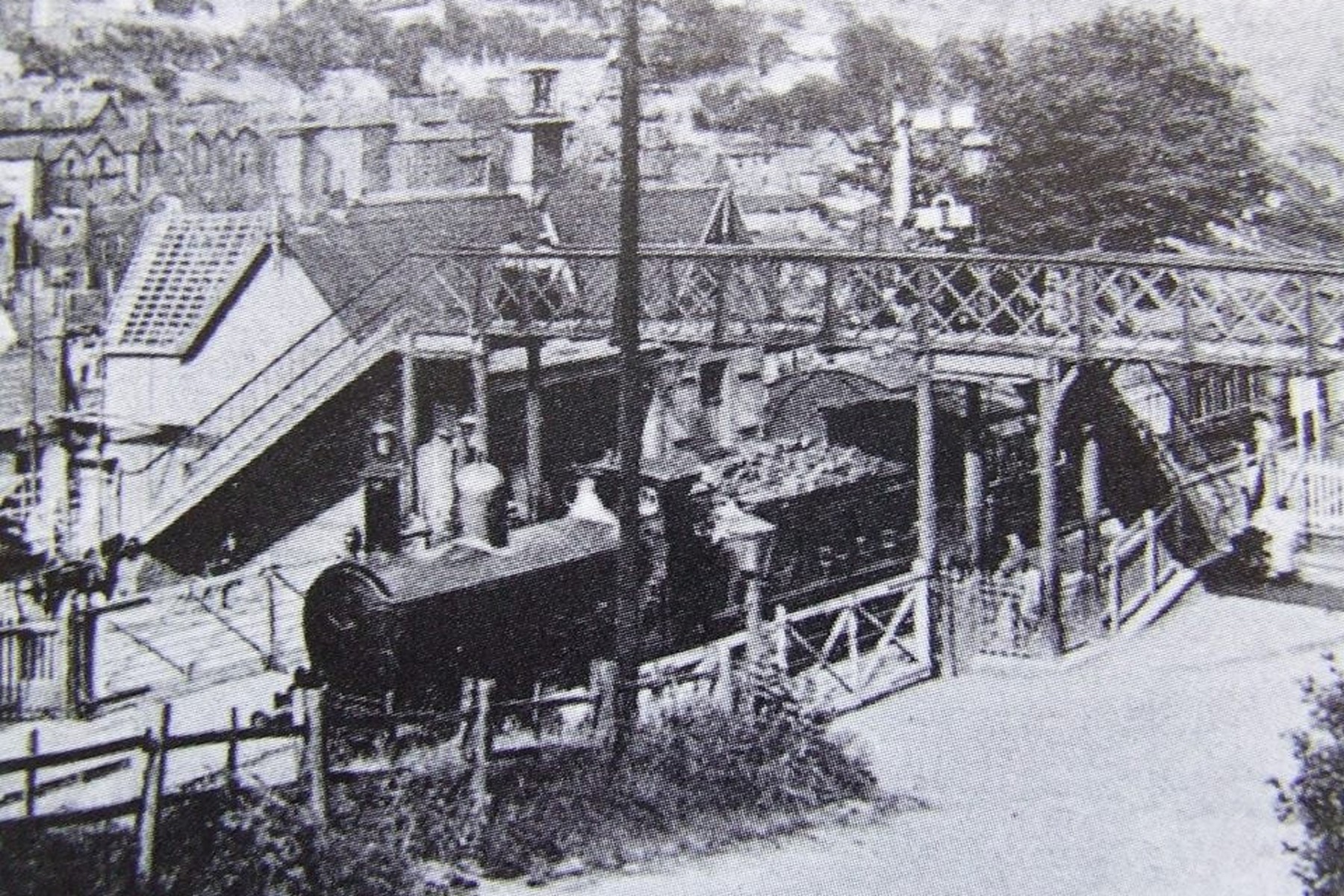
The level crossing, gates and lattice footbridge, looking up to the Tontine Hotel
Local history

A digital exhibition · Severn Valley Railway

Iron bridge & Broseley Railway Station

The railway that connected the Ironbridge Gorge to the world.

Scroll to explore ↓

Chapter one

Building the railway

Ironbridge and Broseley station once stood proudly on the Severn Valley Railway line, serving both the town of Broseley and the town of Ironbridge.

Opened in 1862, it featured two through platforms, a signal box, a level crossing leading to the famous Iron Bridge, a footbridge, and a goods yard complete with a wooden shed. At its height in the 1920s, staff records show 17 employees worked there, including those covering Jackfield sidings and Maw & Co’s Siding.

The station’s name was never entirely fixed. Officially “Ironbridge and Broseley” at opening, it was altered in 1895 to “Iron-Bridge and Broseley” on the recommendation of the General Manager, though the signal box carried the simpler “Iron Bridge & Broseley.”

A British Railways diesel railcar approaches the relocated wooden platform at Jackfield Halt in 1963, shortly before the axe fell. The northern section of the Severn Valley Line closed to passenger traffic that September, and this image captures the last flicker of ordinary service before the timetable, and the trains, stopped running for good.1963The northern section of the Severn Valley Line closed to passenger traffic in September 1963; this view shows a diesel railcar at Jackfield Halt shortly before closure.
Opened
1862
Line
Severn Valley Railway
Platforms
Two through platforms
Staff in the 1920s
17
Passenger closure
9 September 1963
Goods closure
1 December 1963
A newspaper cutting, reproduced from a photograph that once hung inside the station itself, shows staff posed proudly beside the brand-new “Ironbridge and Broseley” nameboard on 9 November 1895. The date marks the moment the station was renamed from plain “Ironbridge”, and the image preserves the faces of the men who actually ran it.9 November 1895Marks the renaming of the station from simply “Ironbridge”, and records the men who ran it.

On paper

The line as the surveyors drew it

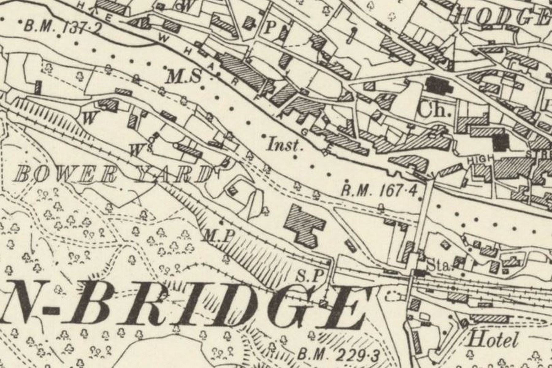
This colour-tinted Ordnance Survey extract, drawn up sometime in the late Victorian or Edwardian years, plots the station, the River Severn and the line threading through the Gorge. Trace the route with your eye and you'll see just how little room the surveyors had to work with, the railway hemmed in on both sides.Late Victorian / Edwardian surveyShows how tightly the railway was squeezed between the Severn and the valley side.

Chapter two

Setting and use

Its location was distinctive. Built on the west bank of the River Severn, which runs almost east-west at this point, it was effectively on the south side of the bridge. The Gorge is narrow here, and much of the station stood on an embankment and plateau held by a 15-metre retaining wall.

The station was probably used more by the people of Broseley (about half a mile away on the same side of the river), a town with tile and clay pipe making industries. The 1861 census showed the population of Broseley as 4,724, larger than Ironbridge (3,154).

Ironbridge town itself is on the north bank, and crossing the bridge required payment of a toll until 1950, a fact that would have discouraged passengers from Ironbridge using the station. Nearby Coalbrookdale, also on the north bank, had its own station on the Wellington–Much Wenlock line.

Platform life

The town on the platform

A British Railways diesel railcar approaches the relocated wooden platform at Jackfield Halt in 1963, shortly before the axe fell. The northern section of the Severn Valley Line closed to passenger traffic that September, and this image captures the last flicker of ordinary service before the timetable, and the trains, stopped running for good.1963The northern section of the Severn Valley Line closed to passenger traffic in September 1963; this view shows a diesel railcar at Jackfield Halt shortly before closure.
Captioned at the time simply “To see them off,” this photograph shows the platform and footbridge packed with the people of Ironbridge seeing their men off to war. Whole families turned out for a departure like this — some of the men they waved away would never return, and some would come home broken. It is not a scene of ordinary station life, and it was never meant to be remembered as one.First World War eraThe town turned out to see the men of Ironbridge off to war — some would never return.
Captioned “Coming over the Bridge,” this photograph shows the crowd streaming across the Iron Bridge and down towards the station to see the men of Ironbridge off to war. Many of those being seen off would never come back to cross the bridge again. The number of people in the road tells you what the day meant to the town.First World War eraCrowds crossed the Iron Bridge to see the men of Ironbridge off to war.
“England – Germany. 1914. D. Coy Ironbridge, 4th Bn King's Shropshire Light Infantry” reads the original caption on this 1914 photograph of the Ironbridge company at the outbreak of the First World War. The railway would soon carry men exactly like these away from the Gorge, many never to return.1914The Ironbridge company photographed at the outbreak of war; the railway carried men like these away from the Gorge.
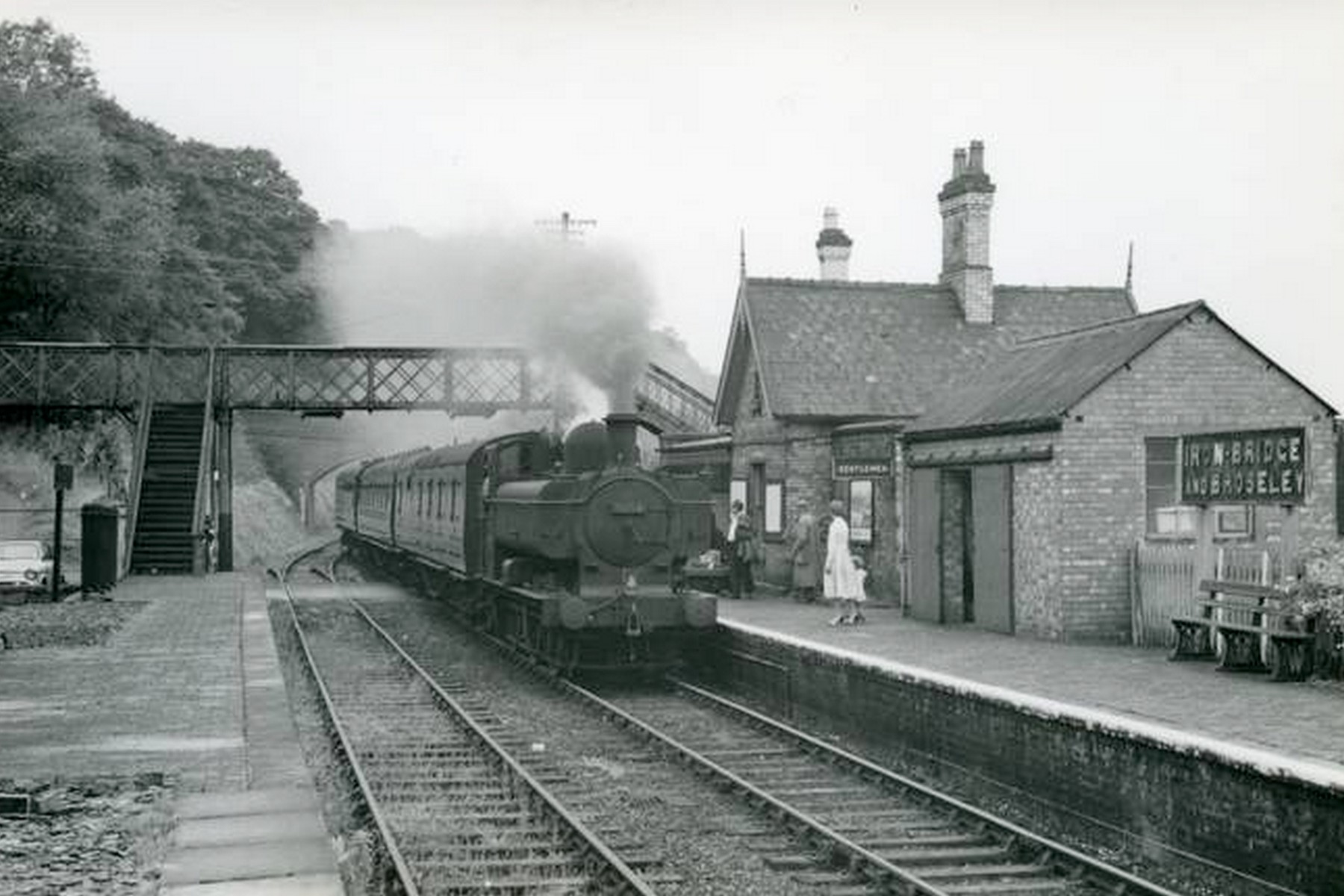
A locomotive runs in as passengers wait patiently along the platform edge in this undated photograph from the steam era. Nothing dramatic is happening here, which is precisely the point — it's a snapshot of the everyday routine at a modest two-platform country station going about its ordinary business, likely sometime in the early 20th century.Exact date unknown — early 20th century, steam eraEveryday platform life at a two-platform country station.
“At its height in the 1920s, staff records show 17 employees worked there.”

The steam era

Engines in the Gorge

Arrivals, departures and through workings, photographed from the platform ends over the station's last decades.

A tank engine waits alongside the platform with its carriages in this early 20th-century view, the down starter signal standing sentinel beside the track. It's one of the clearest surviving images of platform edge, signal and station awning together, capturing the everyday rhythm of a working country station before living memory.Early 1900sOne of the clearest views of the platform edge, signal and station awning together.
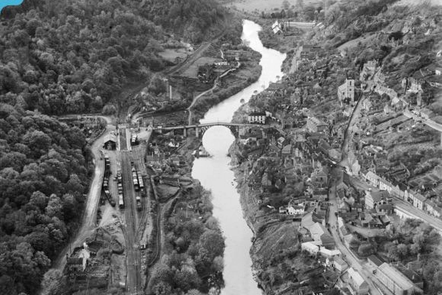
This high-angle, undated photograph from around the mid 20th century sweeps across the Gorge, taking in the railway yard and the Iron Bridge together in a single frame. It's a rare chance to see the full extent of railway land on the west bank before later redevelopment reshaped the area beyond recognition.Exact date unknown — mid 20th centuryShows the full extent of the railway land on the west bank.

The footbridge

The lattice bridge over the line

The footbridge appears in almost every photograph of the station. Seen across the decades, it is the one structure that fixes every other view in place.

Exact date unknown — colourised

This undated, colourised photograph looks along the platform towards the footbridge and signal box, bringing footbridge, box and platform buildings together into a single frame. It's an unusually complete view of the station's working infrastructure, giving a good sense of how compact and self-contained the whole site actually was.

Footbridge, box and platform buildings in a single view.

1960s

Photographed in the 1960s, this view of the footbridge and station approach shows Ironbridge climbing the hillside directly behind. The steepness of that slope explains a great deal about the station's cramped layout — there was simply nowhere else to put it, squeezed as it was beneath the town it served.

Shows how directly the station sat beneath the town.

Early 1960s

A diesel railcar waits at the crossing in this early 1960s photograph, cyclists and passengers gathered patiently by the gates. By this point steam had begun giving way to railcars on local services, a quiet technological shift that arrived only shortly before passenger trains stopped running here altogether in 1963.

The last years of passenger services, after steam had begun to give way to railcars.

Signals & crossing

Working the railway

A signalman looks out from the window of the “Iron Bridge & Broseley” signal box in this photograph taken before 1956, the year the box closed for good. Its token instruments were then moved into the Station Master's office, a small but telling sign of the gradual simplification that preceded full closure.Before 1956The box closed in 1956 and its token instruments moved to the Station Master's office.
Looking down over the platforms, pointwork, sidings and goods shed in this undated photograph from the station's later years, the full track layout is laid bare in a way the old survey maps could only hint at. It remains the clearest single image of how the whole site actually worked.Exact date unknown — later yearsThe clearest photograph of the track layout that the survey maps only outline.
This undated, colourised photograph looks down on the crossing gates and up the bank towards the Tontine Hotel and the town beyond. The road from the station ran straight over this crossing and on to the Iron Bridge, tying rail and river crossing together in one continuous route through the Gorge.Exact date unknown — colourisedThe road from the station ran straight over the crossing and onto the Iron Bridge.

Chapter three

Decline and closure

Rationalisation began in the 1950s.

  • The signal box closed in 1956, with its token instruments moved to the Station Master’s office.
  • Passenger services ceased on 9 September 1963.
  • Goods services ended on 1 December 1963.

By 1966, the station was demolished and its footprint turned into a car park.

Today, little remains beyond a few rails in the roadway and an old gatepost, with Telford Central now the nearest station for visitors to the Gorge.

The buildings

Brick, canopy and decay

1963–1966

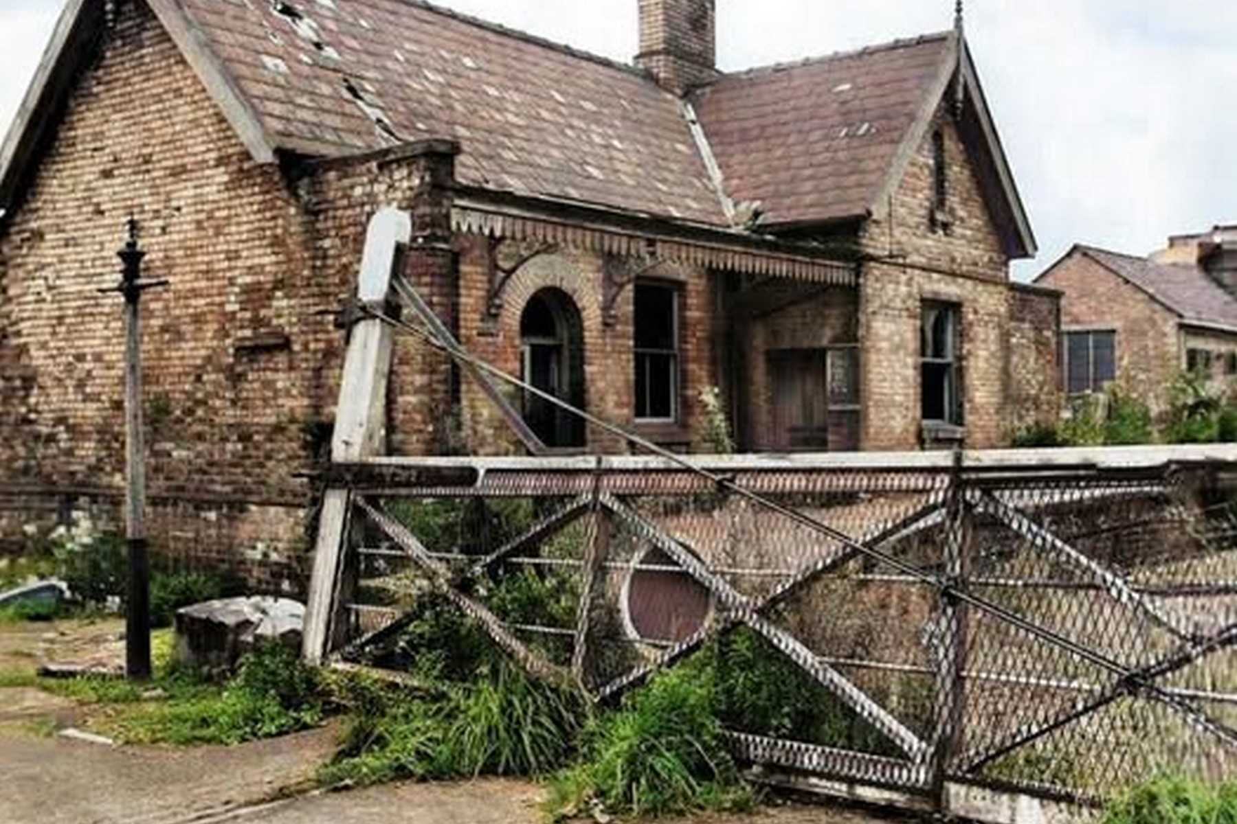
Photographed sometime between the line's closure in 1963 and demolition in 1966, this image shows the abandoned station house and crossing gates, roof failing and windows dark. The decorated brickwork and canopy detail still visible here were lost entirely once the site was cleared, so this is one of the last records of them.

The decorated brickwork and canopy detail visible here were lost when the site was cleared.

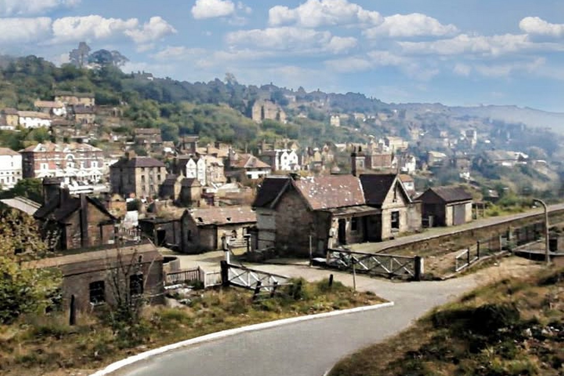
Photographed in the mid 1960s after passenger services had ended, this view shows the station site with its buildings still standing among the rooftops of Ironbridge. It's effectively the last photographic record of the complete station before demolition swept the buildings away not long afterwards, leaving little trace above ground.Mid 1960sThe last view of the complete station before demolition.

Then & now

The same ground, a century apart

Drag each handle to fade between the working railway and the site as it stands today.

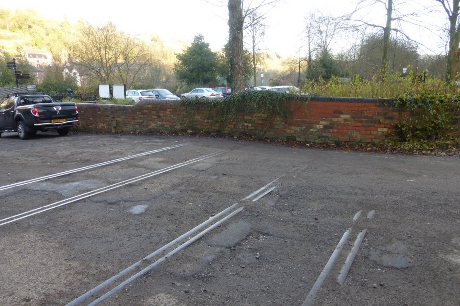
A present-day photograph shows rails still set into the surface of the car park that replaced the station after demolition. Easy to walk straight past without noticing, these buried lengths of track are the single most obvious physical trace of the Severn Valley line left anywhere in Ironbridge today.
Photographed sometime between the line's closure in 1963 and demolition in 1966, this image shows the abandoned station house and crossing gates, roof failing and windows dark. The decorated brickwork and canopy detail still visible here were lost entirely once the site was cleared, so this is one of the last records of them.Then
Now
The station house and gates, and the car park surface that replaced them
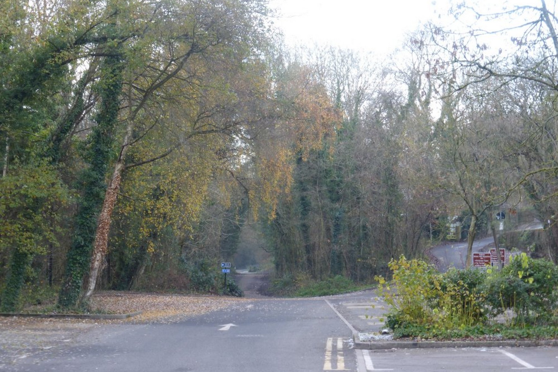
This present-day photograph shows the former railway approach, now a quiet road junction with the old trackbed leading off into the trees. Stand at this spot and you are looking directly along the line the trains once took, even though almost every trace of the railway itself has long since vanished.
Photographed in the mid 1960s after passenger services had ended, this view shows the station site with its buildings still standing among the rooftops of Ironbridge. It's effectively the last photographic record of the complete station before demolition swept the buildings away not long afterwards, leaving little trace above ground.Then
Now
The station approach after closure, and the same approach today
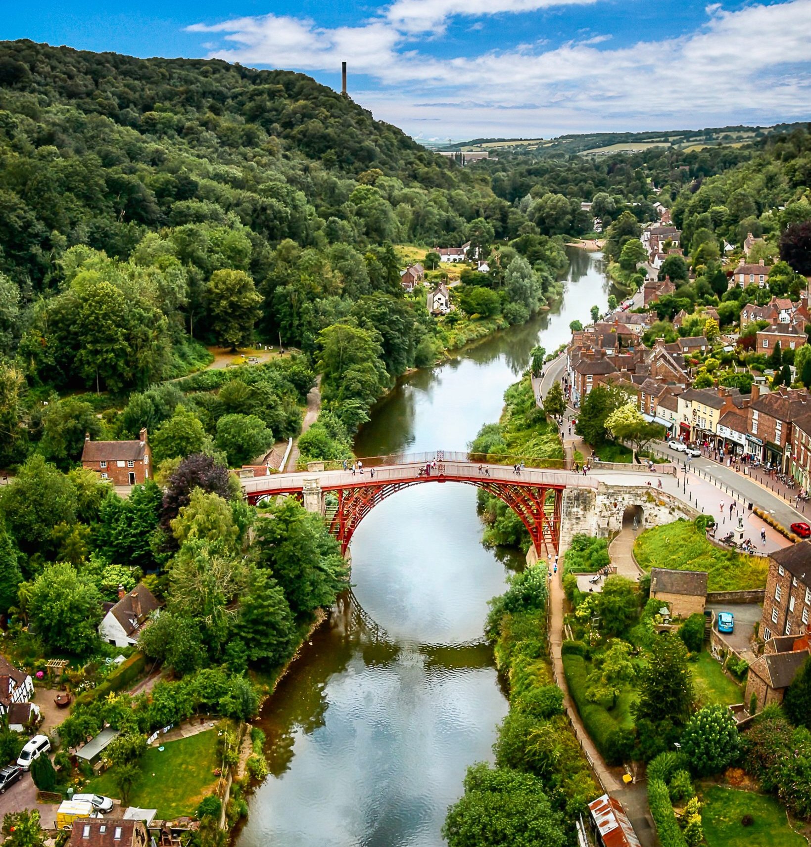
A present-day photograph of the same sweep of the Gorge, taken from roughly the same vantage point as its archive counterpart. Where sidings and railway buildings once stood there is now car park and trees, a striking visual reminder of just how completely the railway's presence has been absorbed back into the landscape.
This high-angle, undated photograph from around the mid 20th century sweeps across the Gorge, taking in the railway yard and the Iron Bridge together in a single frame. It's a rare chance to see the full extent of railway land on the west bank before later redevelopment reshaped the area beyond recognition.Then
Now
Across the Gorge: railway land on the west bank, then and now
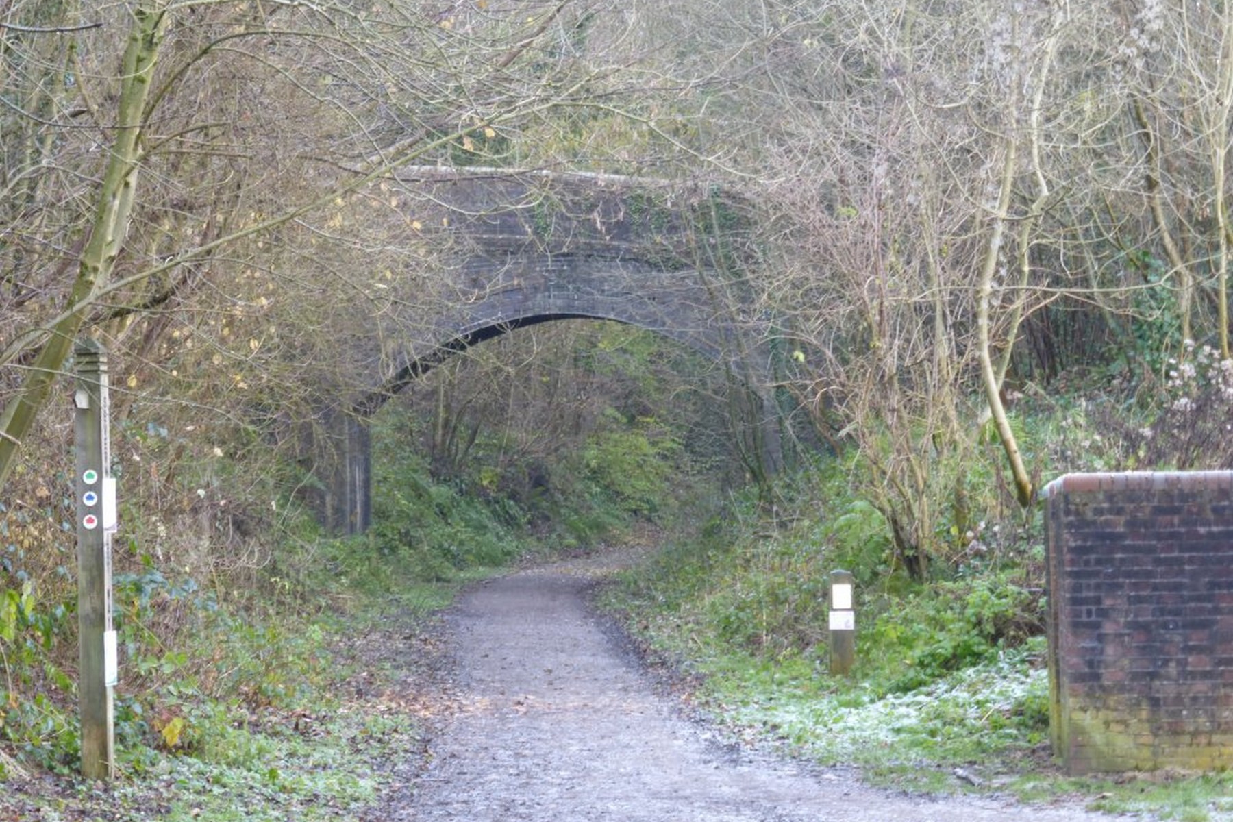
A brick overbridge still arches across the trackbed on the railway walk in this present-day photograph, its stonework largely unaltered since the line closed. It remains a genuine piece of original railway engineering, quietly carrying a road over a route that the trains themselves abandoned back in the 1960s.
A small steam locomotive draws its train beneath the lattice footbridge in this undated photograph from the steam era. The bridge itself spanned the running lines at the west end of the platforms, letting passengers cross safely above the tracks — a structural detail that survived long after the trains themselves stopped running.Then
Now
Under the bridges: a train on the line, and the trackbed as a walking route
Surviving rails still set into the car park surface on the former station site
The level crossing, gates and lattice footbridge, looking up to the Tontine HotelThen
Now
Drag or use arrow keys — the working railway, and the same ground today

Explore the site

Where everything stood

Tap a marker on the old survey map to see what occupied that part of the Gorge.

Ordnance Survey map showing the station, sidings and level crossing beside the Iron Bridge

Station building

“Sta.” on the Ordnance Survey map — the station stood on the west bank, effectively on the south side of the Iron Bridge.

Ordnance Survey map showing the station, sidings and level crossing beside the Iron Bridge

Hidden in plain sight

Railway features you can still find

Surviving rails still set into the car park surface on the former station site

Original rails

A few rails still run through the roadway on the old station site — the clearest surviving trace of the Severn Valley line in Ironbridge.

Surviving rails still set into the car park surface on the former station site

The old gatepost

Beyond the rails, an old gatepost is almost all that is left of the station's fittings after demolition in 1966.

Surviving rails still set into the car park surface on the former station site

Station forecourt and car park

By 1966 the station had been demolished and its footprint turned into a car park — the level ground you park on is the station itself.

The station approach today — the trackbed leads away into the trees

The trackbed

The trackbed remains largely clear from here through to Jackfield, though modern homes now sit directly across parts of it.

Aerial view of the Gorge, with the station, goods yard and sidings filling the west bank

The retaining wall

Much of the station stood on an embankment and plateau held by a 15-metre retaining wall — the Gorge is very narrow at this point.

The level crossing, gates and lattice footbridge, looking up to the Tontine Hotel

The crossing to the Iron Bridge

A level crossing carried the road from the station straight to the famous Iron Bridge, where a toll was payable until 1950.

Aerial view of the Gorge, with the station, goods yard and sidings filling the west bank

Goods yard site

The goods yard, complete with a wooden shed, spread along the west bank — its shape is still legible in the aerial view.

On the ground

Walking the lost railway

A present-day photograph shows rails still set into the surface of the car park that replaced the station after demolition. Easy to walk straight past without noticing, these buried lengths of track are the single most obvious physical trace of the Severn Valley line left anywhere in Ironbridge today.Present dayThe most obvious surviving trace of the Severn Valley line in Ironbridge.
This present-day photograph shows the former railway approach, now a quiet road junction with the old trackbed leading off into the trees. Stand at this spot and you are looking directly along the line the trains once took, even though almost every trace of the railway itself has long since vanished.Present dayStand here and you are looking straight along the old line.
A brick overbridge still arches across the trackbed on the railway walk in this present-day photograph, its stonework largely unaltered since the line closed. It remains a genuine piece of original railway engineering, quietly carrying a road over a route that the trains themselves abandoned back in the 1960s.Present dayOriginal railway engineering, still carrying a road over a line that has gone.
Surviving rails still set into the car park surface on the former station site
The station approach today — the trackbed leads away into the trees

Today, little remains beyond a few rails in the roadway and an old gatepost, with Telford Central now the nearest station for visitors to the Gorge.

Chapter four

Reinstating the Ironbridge Railway: dream or possibility?

The idea of trains once again winding their way into Ironbridge sparks both excitement and debate. The old trackbed tells a story of opportunity, but also of challenge.

On paper, parts of the route still look feasible. The line could be slewed off just before Bramble Ridge Close in Bridgnorth, looping behind the houses and rejoining beyond the golf course. From there, the trackbed remains largely clear through to Jackfield, though some modern homes now sit directly across it.

Costs wouldn’t be small. Even second-hand rail comes in at around £250,000 per quarter mile, with turnouts costing another £50,000 each, and that’s before sleepers, ballast, and labour.

North of Bridgnorth, the line once carried trains at 55mph, a thrilling thought for anyone who imagines driving it again. But the Severn Valley Railway, already stretched with the demands of its heritage line, cannot realistically take on such an extension. If another operator were to build and run it, discussions over access to Bridgnorth station might follow, but it would be a separate venture altogether.

Some see a future in lighter, more modern solutions. The line towards Buildwas has been maintained, and with the power station redevelopment well underway, nothing is completely off the table. The Ironbridge Railway Trust has put forward proposals for a Park & Ride at Buildwas, with services running into the Gorge, not just steam, but potentially modern, environmentally-friendly stock such as lightweight units or even Parry People Mover-style prototypes.

Government funding streams like the “Restoring Your Railway Fund” have been targeted for feasibility studies, though not all bids have succeeded.

Chapter five

The big obstacles

The Gorge has a history of headaches. Jackfield has always been unstable. Tile waste laid over clay, combined with poor drainage, meant the line shifted almost every time a train passed. Maintenance costs were enormous, and instability was a key reason the railway closed in the first place. The infamous 1952 slip is still remembered.

Since then, major stabilisation work has been carried out, most notably the £8 million Jackfield Stabilisation Project between 2015 and 2017, which drove piles deep into the ground, reinforced riverbanks, and realigned roads. Across the Gorge, over £30 million has been spent on stabilisation, but while the risks are now reduced, they haven’t disappeared.

Then there are the practical hurdles. Houses now line parts of the old route, raising access and safety concerns. The costs of levelling and relaying track would be staggering.

A more achievable option, some argue, might be the Madeley Junction to Coalbrookdale stretch, where the trackbed remains intact and could tie neatly into Telford’s Park & Ride system. Even so, bridges and viaducts would need significant work.

The Albert Edward Bridge, for example, could probably take light rail more easily than the heavy freight it once carried, but as both track and bridge are owned by Network Rail, the funding responsibility would sit squarely with them.

Epilogue

A story that isn’t finished

Still, the romance of it lingers. Long before roads took over, the river was Ironbridge’s motorway, and later the railway was its artery.

To many, the idea of steam or diesel services returning is more than nostalgia. It’s a vision of packed weekdays, thriving businesses, and visitors arriving in the Gorge by train, just as they once did.

In the end, it is a vision balanced on a knife-edge: alluring, but weighed down by cost, land, and logistics.

A heritage dream, perhaps, but as with so much in Ironbridge, the story is never quite finished. Who knows what the future might bring?
Take it with you

Can you still spot the railway?

Tick these off as you walk the old station site and trackbed. 0/8 found.

Have photographs of the station? Old snapshots of the platforms, footbridge, signal box or locomotives would help grow this exhibition — send them to us on Facebook and we’ll add them with a credit.

Keep exploring

Continue exploring the Gorge