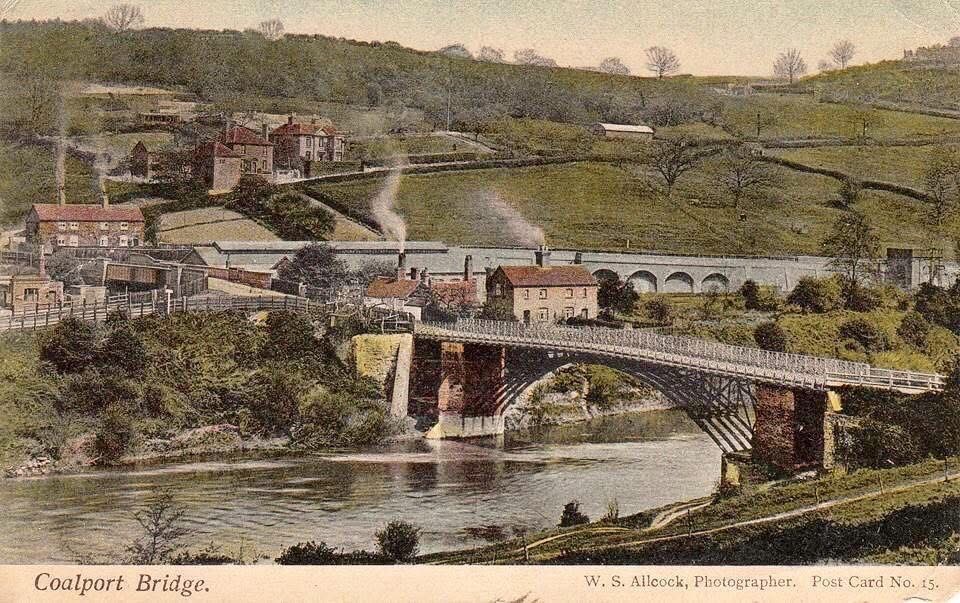
This hand-tinted postcard, W. S. Allcock's Post Card No. 15 from the early 1900s, gives the classic view of Coalport Bridge from the Shropshire bank. Look closely at the single cast-iron arch and the toll house at its northern end — the colourist's guesswork with the brickwork tones is part of what makes these cards such charming, if not always accurate, historical documents.
Local history

A digital exhibition · Coalport & Broseley

Coalport Bridge & its Toll Houses

A timber crossing of 1780, rebuilt in cast iron in 1818, and two toll houses that took your money twice — the story of the Gorge's working bridge, told through 43 photographs and the newspapers of the day.

Scroll to explore ↓

Coalport Bridge is one of the Ironbridge Gorge's hidden engineering treasures. Opened in 1818, its elegant cast iron arch has carried people across the River Severn for more than two centuries.

Alongside it stand two toll houses — the cottage at the end of the deck and the turnpike “catchgate” up the hill — each with its own story of the people who took your money to let you cross.

Built
1818
Bridge type
Cast iron
Bridge listing
Grade II* listed
Toll house listing
Grade II listed
River
River Severn
Weight limit
3 tonnes mgw
Traffic
One vehicle at a time
Setting
UNESCO World Heritage Site
First crossing
1780, timber

Chapter one

Coalport before the bridge

A bend in the Severn where canal, railway, china works and river trade all met — and where, for centuries, the only way across was a ferry.

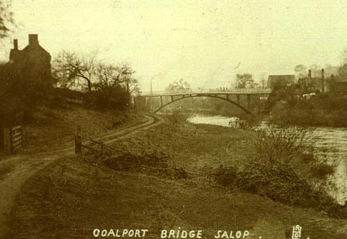
Titled “Coalport Bridge, Salop”, this early-1900s postcard shows the unmade approach road running alongside the river. Look at the rutted, rough surface underfoot — nothing like today's tarmac. It's a useful corrective to any romantic idea of Edwardian travel: reaching the bridge meant picking your way over industrial trackways, mud and all.Early 1900sA reminder that the bridge was reached by rough industrial trackways, not the tarmac of today.

Coalport, set deep in the Ironbridge Gorge, has always been about crossings — turnpike roads, iron spans, and toll gates that took your money whether you were on foot, horseback, or hauling a wagonload of coal.

To this day, people still mix up the two toll houses at Coalport. In truth, they had very different roles: one collected for the bridge, the other for the road. Together, they tell a story of industry, Parliament, and the everyday lives of the people who manned the gates.

Chapter two

Why a bridge was needed

An Act of Parliament in 1776, a timber crossing by 1780, and a river that twice proved it was not enough.

“Coalport Bridge, R. Severn” reads the caption on this early-1900s card, taken from downstream so the whole span sits low against the water. Notice just how little clearance there is between the iron arch and the river's surface — a design compromise that has made flooding the bridge's oldest and most persistent enemy.Early 1900sShows how low the iron arch sits above the water, and why floods have always been the bridge's enemy.

The first bridge at Preen’s Eddy, later known as Coalport Bridge, was completed in 1780 under an Act of 1776 to provide a much-needed crossing of the River Severn at Preens Eddy, the hamlet on the south bank of the river.

Here, the industrial settlement of Coalport on the north bank was expanding rapidly, while Broseley and Jackfield on the south bank had long-established collieries, potteries, and ironworks. A permanent bridge was essential to connect these communities, replacing reliance on ferries and giving direct access to the Coalport China Works and the growing trade of the Gorge.

The first bridge, completed in 1780, was of timber construction. Its creation was entirely funded by private subscription, with shareholders hoping to recoup their investment through tolls on every wagon, cart, horse, or pedestrian that crossed.

The bridge was designed by William Hayward and built by Robert Palmer, a Madeley timber merchant. During a flood in 1795, the middle pier was badly damaged, and the original two-span design had to be reconsidered.

Unfortunately, the wooden span did not prove durable. It was battered by floods, weakened by heavy use, and within twenty years had to be replaced.

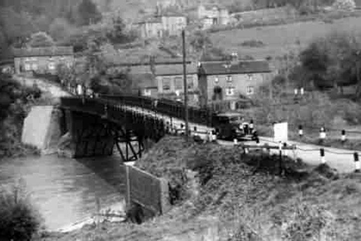
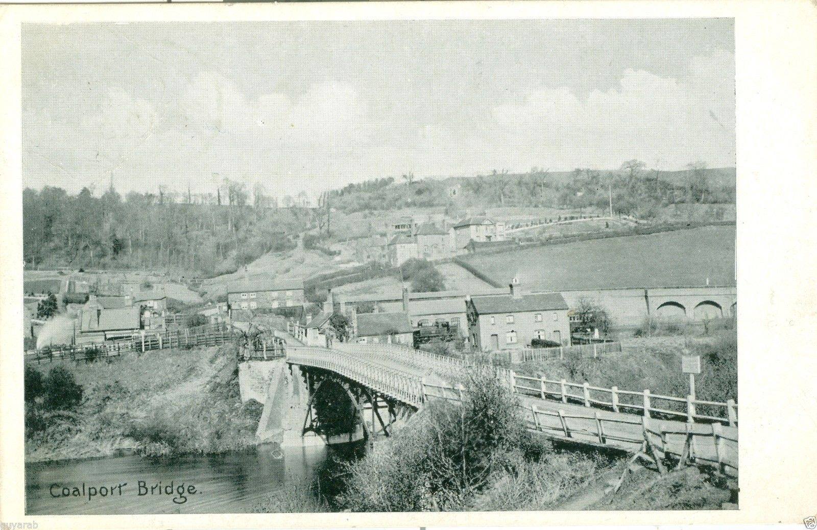
A plain monochrome postcard, simply captioned “Coalport Bridge” and printed sometime in the early 1900s. Notice how the china works village climbs the hillside behind the deck — a reminder that this crossing existed to serve industry first, and travellers second, in the years when Coalport pottery was shipped downriver from here.Early 1900sTaken from the Coalport side, with the china works village climbing the valley behind the deck.
This hand-tinted postcard, W. S. Allcock's Post Card No. 15 from the early 1900s, gives the classic view of Coalport Bridge from the Shropshire bank. Look closely at the single cast-iron arch and the toll house at its northern end — the colourist's guesswork with the brickwork tones is part of what makes these cards such charming, if not always accurate, historical documents.Early 1900sThe classic view: the single cast-iron arch, the toll house at the north end and the wharf cottages behind.

Chapter three

Building the 1818 bridge

John Onions of Broseley cast a single iron arch and landed it on the abutments of the old timber bridge.

Photographed from the water's edge sometime in the twentieth century, this study captures the cast-iron arch ribs and their radiating spandrel bracing in close detail. Look for the slender paired ribs carrying the deck — John Onions' 1818 design cleverly reused the older abutments beneath, saving cost while giving the bridge its distinctive lightness.Late 20th centuryJohn Onions' 1818 design reused the older abutments and carried the deck on slender paired ribs.

In 1818, local ironmaster John Onions rebuilt the bridge entirely in cast iron, reusing the old abutments. His design proved resilient, standing nearly 200 years.

Although less celebrated than the Iron Bridge, the Coalport crossing was far more affordable and quickly became the preferred route for locals and industry.

A bridge of iron, thrown in one arch across the Severn, where a bridge of timber had twice been beaten by the river.

On the 1818 rebuild
A close view of the cast-iron nameplate reading COALPORT BRIDGE 1818, set into the parapet where every crossing traveller would have passed it. This small plate is the bridge's own signature: it records the exact year John Onions rebuilt the earlier timber and masonry crossing in iron, the moment the structure we see today truly began.Cast 1818Set into the parapet, this plate records the year John Onions rebuilt the crossing in iron.
This twentieth-century photograph focuses on the point where the arch springs from its brick abutment, the lattice parapet visible above. It's worth pausing on that junction of brick and iron: it is the oldest surviving fabric on the site, dating back to the timber bridge first built here in 1780.Late 20th centuryThe junction of brick and iron is the oldest surviving fabric, dating from the 1780 timber bridge.

Chapter four

The engineering

Ribs, spandrels, parapet and abutment — the parts of the bridge that tell you how it was built, and how often it has been patched.

A colour photograph taken from the Broseley bank, looking up under the deck at the exposed ironwork. Study the patched and sprayed surfaces closely and you can trace three separate repair campaigns — 1961, 1969, and 2004–05 — each generation of engineers grappling anew with keeping this Georgian ironwork roadworthy.Present dayRepairs of 1961, 1969 and 2004–05 are all visible in the patched and sprayed surfaces.

Span

c.29 m single arch

One cast-iron arch clears the whole channel, so nothing stands in the river to catch flood debris.
Ribs

Paired cast-iron ribs

Slender ribs carry the deck, braced by radiating spandrel members cast at local foundries.

Abutments

Brick, 1780

The oldest fabric on site: the iron of 1818 was landed on the abutments of the earlier timber bridge.

Parapet

Circle-and-lozenge

The decorative railing pattern runs the full length of the deck and is original to the rebuild.

Founder

John Onions, 1818

Broseley ironmaster whose name and date are cast into the plate set in the parapet.

Loading today

3 t mgw, one vehicle

Barriers and weight signs keep modern loads inside what 200-year-old cast iron can safely carry.

Late 20th century

Photographed from the water's edge sometime in the twentieth century, this study captures the cast-iron arch ribs and their radiating spandrel bracing in close detail. Look for the slender paired ribs carrying the deck — John Onions' 1818 design cleverly reused the older abutments beneath, saving cost while giving the bridge its distinctive lightness.

John Onions' 1818 design reused the older abutments and carried the deck on slender paired ribs.

Late 20th century

This twentieth-century photograph focuses on the point where the arch springs from its brick abutment, the lattice parapet visible above. It's worth pausing on that junction of brick and iron: it is the oldest surviving fabric on the site, dating back to the timber bridge first built here in 1780.

The junction of brick and iron is the oldest surviving fabric, dating from the 1780 timber bridge.

Present day

A colour photograph taken from the Broseley bank, looking up under the deck at the exposed ironwork. Study the patched and sprayed surfaces closely and you can trace three separate repair campaigns — 1961, 1969, and 2004–05 — each generation of engineers grappling anew with keeping this Georgian ironwork roadworthy.

Repairs of 1961, 1969 and 2004–05 are all visible in the patched and sprayed surfaces.

Present day

Looking along the underside of the deck towards the Coalport abutment, this modern photograph reveals the decorative circle-and-lozenge parapet pattern running the full length of the span. Cast at local foundries, that repeating motif was as much a display of engineering pride as it was structural bracing, and it still defines the bridge's silhouette today.

The decorative circle-and-lozenge parapet, cast at local foundries, runs the full length of the span.

Cast 1818

A close view of the cast-iron nameplate reading COALPORT BRIDGE 1818, set into the parapet where every crossing traveller would have passed it. This small plate is the bridge's own signature: it records the exact year John Onions rebuilt the earlier timber and masonry crossing in iron, the moment the structure we see today truly began.

Set into the parapet, this plate records the year John Onions rebuilt the crossing in iron.

Chapter five

Paying the toll

Coalport's tolls were a business. Each year the right to collect them was auctioned at an inn in Broseley — and whoever won stood at the gate and made what he could of it.

A horse and trap pauses at the gate beside the toll house in this early-1900s photograph. Every cart that passed here paid its due — sixpence to a shilling depending on how many horses were in the shafts — a system of tolls that funded the bridge's upkeep for well over a century.Early 1900sEvery cart paid: 6d to 1s depending on the number of horses in the shafts.
What the turnpike gate charged
Horse and rider1d
Cart or wagon6d – 1s, by number of horses
Packhorse or mule½d each
Sheep, pigs or calves5d per score (20)
Cattle1d per head

…put up at the sum of two hundred and twenty-five pounds, being the amount let for last year.

Shrewsbury Chronicle, 2 June 1854

Chapter six

The two toll houses

One at the end of the deck, one up the hill: the bridge toll house and the turnpike catchgate, endlessly confused with each other ever since.

The Coalport Bridge Toll House, ivy-clad, with the keeper standing in the doorway around 1900. This modest building had already led several lives by then — a warehouse by 1793, a house by 1815, and a toll house from the 1818 rebuild — making it as much a family home as a place of work.Early 1900sWarehouse by 1793, house by 1815, toll house from the 1818 rebuild — a workplace and a family home.

The Coalport Bridge Toll House stood at the north end of the bridge. It began life as a warehouse (1793–1808), was in use as a house by 1815, and after the 1818 rebuild became the tollhouse and cottage.

Over the years, the building itself was altered several times:

  • c.1860 – a two-storey rear extension was added, after the arrival of the railway, to provide more living space.
  • By 1856 – a wash house stood behind the toll house; this was largely rebuilt during 1994 restoration works.
  • Pre-1883 – further minor additions included a pantry and lean-to structures.
  • 1994–96 – when declared “at risk,” the Buildings at Risk Trust restored and partially rebuilt the toll house, repairing brickwork, roofs, and structural stability.

The building remained in use as a tollhouse and home, owned by the Trustees of Coalport Bridge, until 1922, when tolls were abolished and the bridge passed to Shropshire County Council.

The census returns from 1841 to 1891 provide the occupations of the tenants over a 50-year span. These include schoolmaster, labourer, grocer, shoemaker, wheelwright and modeller in china, as well as the obvious gatekeeper and toll collector.

This shows the toll house was not just an office but a lived-in home, where families balanced toll duties with other trades tied to the life of the Gorge.

By the 1960s, the building had a new identity. Locals remember it as a shop run by Mrs Green, with customers entering through the stable-style door at the front.

After 1922, it carried on as a cottage but slipped into decline. By the 1970s it was semi-derelict. In March 1974, the Council moved to sell it, and by 1975 it had passed into the care of the Ironbridge Gorge Museum Trust. Later, the Buildings at Risk Trust oversaw its restoration before it was sold into private ownership.

Today it is a Grade II listed building (designated 2002).

After crossing the bridge from Broseley into Coalport, travellers soon encountered a turnpike gate on the approach road leading down into the village and the wharves.

This was part of the Madeley–Broseley–Coalport Turnpike Trust, established in the late 18th century to maintain the steep and heavily used road. The small cottage here became known locally in later years as the Old Toll House, to distinguish it from the toll house at the bridge itself.

Locals often called it the “catchgate” — because it “caught you” for another toll right after you had crossed the bridge.

Tolls charged at the gate followed the standard Shropshire turnpike rates:

  • 1d for a horse and rider
  • 6d to 1s for carts or wagons, depending on how many horses pulled them
  • ½d per packhorse or mule
  • 5d per score (20 animals) for sheep, pigs, or calves
  • 1d per head for cattle

For local industry, those pennies soon mounted up. Carts of coal, clay, or china bound for the wharf could pay here after already paying to cross the bridge, meaning some journeys cost two tolls in quick succession.

The toll house itself was built in the late 18th century, with distinctive spy holes still visible, used by the keeper to watch for toll-dodgers.

The house fell into disrepair and was semi-derelict. It was originally renovated by Mick Beers and his brother Wilson in the early 1970s. Mick and Wilson are responsible for saving various old houses locally.

Today it survives as a two-bedroom Airbnb or holiday let, but the name “Old Toll House” — adopted locally in the 20th century — still clings to it.

The Coalport Bridge Toll House, ivy-clad, with the keeper standing in the doorway around 1900. This modest building had already led several lives by then — a warehouse by 1793, a house by 1815, and a toll house from the 1818 rebuild — making it as much a family home as a place of work.Early 1900sWarehouse by 1793, house by 1815, toll house from the 1818 rebuild — a workplace and a family home.
A horse and trap pauses at the gate beside the toll house in this early-1900s photograph. Every cart that passed here paid its due — sixpence to a shilling depending on how many horses were in the shafts — a system of tolls that funded the bridge's upkeep for well over a century.Early 1900sEvery cart paid: 6d to 1s depending on the number of horses in the shafts.
Villagers gather outside the toll house in this early-1900s photograph, a barrel being rolled towards the gate as everyday business goes on. The image later found new life when the Shropshire Star reprinted it decades on, asking readers to help identify the building — proof of how quickly local memory can fade.Early 1900sOne of the photographs later used by the Shropshire Star when readers were asked to identify the building.
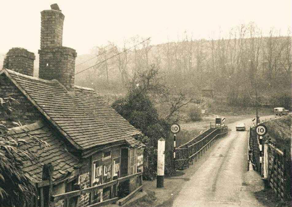
A winter view past the toll house, mid-twentieth century, with 10 mph signs posted at each end of the deck. It's worth noting how early these restrictions began: speed and weight limits were already tightening decades before the heavy modern lorries that eventually forced far stricter controls on this fragile iron crossing.Inter-war yearsSpeed and weight limits were already tightening long before modern lorries arrived.
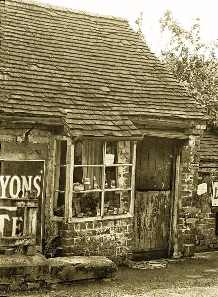
By 1964 the old toll house had become a village shop, Lyons' Tea and Park Drive cigarette signs crowding the window. Older residents still remember buying groceries and cigarettes through its stable-style door — a gentle reminder that this building's toll-collecting days were, by then, a fading local memory rather than lived experience.1964Locals remember buying cigarettes and groceries here through the stable-style door.
Mrs Green, the toll house's mid-twentieth-century shopkeeper, photographed standing on the bridge deck. Look at how ordinary the scene feels — for many locals of this era the building wasn't remembered as a historic toll collector's office at all, but simply as “Mrs Green's”, the corner shop everyone knew.Around the 1950sIn living memory the toll house was “Mrs Green's” rather than a toll collector's office.
Toll house and neighbouring cottage stand together in this mid-twentieth-century view, no-entry and weight-limit signs crowding the approach between them. Visitors today still confuse the two buildings, so look carefully: one is the historic bridge toll house, the other a separate cottage that merely happens to share its doorstep with all this signage.Inter-war yearsThe two buildings that visitors still confuse: the bridge toll house, and the cottage beside it.

Chapter seven

The bridge keeper

The keeper lived where he worked. A century later the same rooms were a village shop, and everyone in Coalport knew it as Mrs Green's.

Villagers gather outside the toll house in this early-1900s photograph, a barrel being rolled towards the gate as everyday business goes on. The image later found new life when the Shropshire Star reprinted it decades on, asking readers to help identify the building — proof of how quickly local memory can fade.Early 1900sOne of the photographs later used by the Shropshire Star when readers were asked to identify the building.
By 1964 the old toll house had become a village shop, Lyons' Tea and Park Drive cigarette signs crowding the window. Older residents still remember buying groceries and cigarettes through its stable-style door — a gentle reminder that this building's toll-collecting days were, by then, a fading local memory rather than lived experience.1964Locals remember buying cigarettes and groceries here through the stable-style door.
Mrs Green, the toll house's mid-twentieth-century shopkeeper, photographed standing on the bridge deck. Look at how ordinary the scene feels — for many locals of this era the building wasn't remembered as a historic toll collector's office at all, but simply as “Mrs Green's”, the corner shop everyone knew.Around the 1950sIn living memory the toll house was “Mrs Green's” rather than a toll collector's office.

By the 1960s the toll house had a new identity. Locals remember it as a shop run by Mrs Green, with customers stepping through the stable-style door at the front for cigarettes, tea and groceries — Lyons' Tea and Park Drive signs still hanging in the window.

Chapter eight

The village around the bridge

In May 1911 the Sutton Coldfield Automobile Club brought its hill climb to Coalport, and the crowds lined the bridge rails.

Competitors and officials gather at the toll gate before the May 1911 hill climb begins. Look past the riders to the gate itself, swung open for the day: this is one of the clearest surviving photographs of the toll gate actually in working use, a detail easy to miss amid all the motorcycling excitement.May 1911The gate itself is the star: this is one of the clearest images of the working bridge gate.

Coalport Bridge wasn’t only about tolls and trade. In May 1911, the Sutton Coldfield Automobile Club chose Coalport Hill as the venue for their annual hill climb.

A photograph from the Ironbridge Gorge Museum archives shows the start of the race right at the bridge. Six classes of cars and motorcycles competed, and the Wellington Journal and Shrewsbury News announced it would be “a most sporting character … where some thrilling riding should be witnessed.”

Crowds line the rails at the start of a hill climb at the bridge in May 1911, watching riders take off up Coalport Hill. The Sutton Coldfield Automobile Club ran this annual event across six classes, turning a working river crossing, for one day a year, into a grandstand for the new sport of motorcycling.May 1911The Sutton Coldfield Automobile Club used Coalport Hill for its annual climb; six classes competed.

Chapter nine

Traffic through the decades

Horses, then motor cars in single file, then lorries the iron was never designed to carry.

Motor cars cross in single file in this 1930s photograph, the village rising behind them up the valley side. By this decade the limits stood at 8 tons and 5 mph — modest figures today, but a sign that even early motor traffic was already asking more of this Georgian ironwork than it was built for.1930sBy this decade the limits were 8 tons and 5 mph — the iron was already being asked too much.
The Broseley approach, photographed in the mid-twentieth century, shows a 10 mph roundel posted at each end of the deck. Traffic control here has never relied on barriers or lights so much as on signs, faith and mutual courtesy between drivers meeting on a bridge built wide enough for one vehicle at a time.Mid 20th centuryTraffic control on the bridge has always been a matter of signs, faith and courtesy.
A hand-lettered sign reads “road closed — you may walk to the Woodbridge through here and over the bridge”, photographed on 22 May 1961. Guniting repair work had shut the bridge entirely to vehicles that spring, and pedestrians could only be squeezed past the works on foot, a rare full closure in the bridge's history.22 May 1961Guniting repairs shut the bridge to vehicles; pedestrians were squeezed past the works.
The bridge and its lifebelt post, seen from the Coalport approach sometime in the 1970s. Traffic here still looks light and unhurried in this decade — a quieter era before HGV routing turned the weight limit into the daily headache it later became for residents and council alike.1970sA quieter era of light traffic, before HGV routing made the weight limit a daily problem.
A winter view past the toll house, mid-twentieth century, with 10 mph signs posted at each end of the deck. It's worth noting how early these restrictions began: speed and weight limits were already tightening decades before the heavy modern lorries that eventually forced far stricter controls on this fragile iron crossing.Inter-war yearsSpeed and weight limits were already tightening long before modern lorries arrived.

Chapter ten

Weight restrictions

Eight tons, then three, then two — and a running argument with the drivers who ignored every sign.

An articulated lorry sits halted in 1983, caught by a newly installed electronic sign reading “overweight — turn back”. Coalport became the first bridge in Britain fitted with this kind of electronic weighing pad, a genuinely pioneering piece of roadside technology deployed simply to protect a two-century-old iron span.1983Coalport became the first bridge in Britain fitted with electronic weighing pads.

Even in iron, Coalport Bridge struggled with modern traffic.

  • By the 1930s, limits were set at 8 tons and 5 mph.
  • In 1961 and 1969, engineers carried out patch repairs by guniting (sprayed concrete).
  • In 1983, Coalport became the first bridge in Britain to be fitted with electronic weighing pads.
  • In 1989, outrage followed reports of a 32-ton lorry attempting to cross.
  • In 1994, County Surveyor Keith Madelin warned the bridge could close if motorists ignored the “one vehicle at a time, 2-ton limit” rule.
  • In 2004–2005, the bridge closed for several weeks for a £1 million strengthening and conservation project.

It remains a Scheduled Ancient Monument, carrying cars in single file under tight restrictions.

Failure of the bridge material would be sudden and without warning.

County Surveyor Keith Madelin, December 1994
Motor cars cross in single file in this 1930s photograph, the village rising behind them up the valley side. By this decade the limits stood at 8 tons and 5 mph — modest figures today, but a sign that even early motor traffic was already asking more of this Georgian ironwork than it was built for.1930sBy this decade the limits were 8 tons and 5 mph — the iron was already being asked too much.
The Broseley approach, photographed in the mid-twentieth century, shows a 10 mph roundel posted at each end of the deck. Traffic control here has never relied on barriers or lights so much as on signs, faith and mutual courtesy between drivers meeting on a bridge built wide enough for one vehicle at a time.Mid 20th centuryTraffic control on the bridge has always been a matter of signs, faith and courtesy.
A hand-lettered sign reads “road closed — you may walk to the Woodbridge through here and over the bridge”, photographed on 22 May 1961. Guniting repair work had shut the bridge entirely to vehicles that spring, and pedestrians could only be squeezed past the works on foot, a rare full closure in the bridge's history.22 May 1961Guniting repairs shut the bridge to vehicles; pedestrians were squeezed past the works.
The bridge and its lifebelt post, seen from the Coalport approach sometime in the 1970s. Traffic here still looks light and unhurried in this decade — a quieter era before HGV routing turned the weight limit into the daily headache it later became for residents and council alike.1970sA quieter era of light traffic, before HGV routing made the weight limit a daily problem.
An articulated lorry sits halted in 1983, caught by a newly installed electronic sign reading “overweight — turn back”. Coalport became the first bridge in Britain fitted with this kind of electronic weighing pad, a genuinely pioneering piece of roadside technology deployed simply to protect a two-century-old iron span.1983Coalport became the first bridge in Britain fitted with electronic weighing pads.
A modern “weak bridge — 3T mgw” sign stands beside the old cast-iron milepost, two very different eras of roadside information side by side. The current limit restricts crossings to three tonnes maximum gross weight, and only one vehicle at a time — a strict regime that keeps the Georgian ironwork in daily use.Present dayThe current limit is three tonnes maximum gross weight, one vehicle at a time.
The signed approach today reads “only one vehicle on bridge”, backed up by height and width barriers across the road. Where a toll keeper once controlled traffic by hand and by conversation, these barriers now do the same job automatically, a quiet but telling shift in how the crossing is managed.Present dayHeight and width barriers now do the work the toll keeper once did by hand.
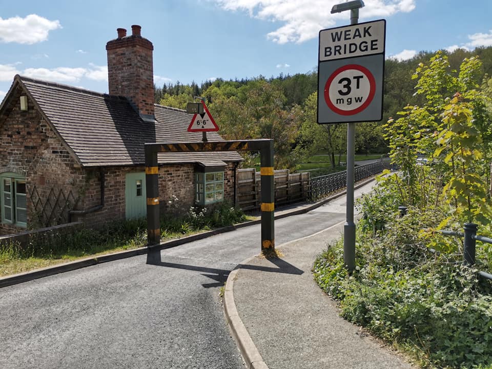
The bridge toll house today, framed by a modern 3T weak-bridge sign standing in front of it. It's a striking single view: two centuries of traffic control captured together, the eighteenth-century gatehouse and the twenty-first-century height barrier both doing essentially the same job of managing who gets across.Present dayTwo centuries of traffic control in one view: the gatehouse and the height barrier.
Further up the approach road stands the “Old Toll House”, once a turnpike catchgate, photographed as it looks today. Look for the small spy holes built into its walls, positioned so the keeper could watch the road without stepping outside. It now operates as a holiday let, its watching days long over.Present dayThe turnpike catchgate house, with its spy holes watching the road. Now a holiday let.

Documents

The story in the newspapers

Six cuttings from the Shropshire press, 1854 to 2011. Tap any clipping to read it full size.

From the archive

Coalport Bridge Tolls to be Let

Shrewsbury Chronicle, 2 June 1854

…put up at the sum of two hundred and twenty-five pounds, being the amount let for last year.

The tolls were not collected for the proprietors directly. They were auctioned each year at the Pheasant Inn in Broseley, and the winning bidder kept whatever he could gather at the gate. Bidders from outside the parish had to leave a month's rent as deposit and find sureties. The notice is signed by John Griffiths, Clerk.

From the archive

Trust wants toll houses

Shropshire Star, 27 March 1974

Salop County Council will be asked … to sell the Iron Bridge Toll House and the Coalport Bridge Toll House to the Ironbridge Gorge Museum Trust.

By the 1970s the Coalport toll house was semi-derelict. The council moved to sell in March 1974 and by 1975 the building had passed into the care of the Ironbridge Gorge Museum Trust — the step that eventually led to its restoration rather than its demolition.

From the archive

Weight check catching up

Shropshire Star, 30 March 1983

The Transport and Road Research Laboratory was today working on new electronic weight detectors at Coalport Bridge.

Coalport became the first bridge in Britain to be fitted with electronic weighing pads set into the road. Overweight vehicles triggered a sign telling the driver to turn back. The system was delayed for weeks by teething troubles before it came into operation.

From the archive

Drivers are warned over lorry weight

Local press, late 1980s

“If I see anyone else exceeding the weight limit on the bridge, I will report them as well and make it a hat trick.”

Broseley parish councillor Philip Robinson told a parish council meeting he had already reported two lorries to the police — one of them a 32-ton vehicle crossing a bridge posted at two tons. The bridge's protection has always depended as much on local vigilance as on signs.

From the archive

Warning over Coalport Bridge

Telford Journal, December 1994

Failure of the bridge material would be sudden and without warning.

County Surveyor Keith Madelin told Shropshire County Council's highways sub-committee that closure was the only option if motorists refused to treat the bridge with the respect it needed. Narrow “gateway” barriers were proposed to physically restrict the width of traffic, alongside the existing one-vehicle-at-a-time rule.

From the archive

Star readers solve mystery of toll house

Shropshire Star, 11 January 2011

Mystery solved: the picture shows Coalport Toll House pre-1914, which still stands.

A reader's unidentified photograph was published in the Star and answered within days. Correspondents recognised the toll house at the north end of the bridge, named the families who had lived there, and recalled a second, smaller toll cottage nearby that has since gone. It is the clearest evidence of how easily the two Coalport toll houses are confused.

Chapter eleven

Restoration

Semi-derelict by the 1970s, scaffolded in 1994, and sold as a home once the roofs and brickwork were sound again.

Scaffolding envelops the long-derelict toll house as restoration begins in the autumn of 1994. The project was reported at the time as intended to see the building “due to be sold as a residence when work is complete” — the Buildings at Risk Trust's rescue of a structure that had stood empty for years.Autumn 1994“Due to be sold as a residence when work is complete” — the Buildings at Risk Trust's rescue.

After the tolls ended in 1922 the building carried on as a cottage, then slipped into decline. By the 1970s it was semi-derelict; in 1974 the council moved to sell, and by 1975 it had passed to the Ironbridge Gorge Museum Trust. Two decades later the Buildings at Risk Trust rebuilt failing brickwork and roofs, and the house was sold as a private residence. It has been Grade II listed since 2002.

Captioned “view from across the River Severn — before”, this early-1990s survey photograph shows the toll house and its outbuildings in a genuinely derelict state. Notice the collapsing roofs and failing brickwork: by this point the building had been officially declared at risk, setting in motion the rescue that followed.Late 20th centuryDeclared a building at risk, with collapsing roofs and failing brickwork.
A then-and-now composite sets the toll house's derelict twentieth-century state directly beside its restored appearance today. Look at the wash house behind the main building in each half — it was largely rebuilt during the 1994–96 works, making it easy to underestimate just how much reconstruction this rescue actually involved.Late 20th century and present dayThe wash house behind was largely rebuilt during the 1994–96 works.

Chapter twelve

Floods and hard winters

The river destroyed the timber bridge's middle pier in 1795. It has been testing the iron ever since.

The Severn in flood, brown water pushing hard against the bridge's abutments in this modern photograph. Floods are nothing new to this site — one destroyed the middle pier of the earlier timber bridge back in 1795 — and the river continues to test the iron structure's foundations to this day.Present dayFlood destroyed the middle pier of the timber bridge in 1795; the river still tests the iron.
The approach under snow, twentieth century, weight and speed signs stacked together at the gate. Winter closes the wider Gorge road network quickly and often, and in those moments this narrow crossing has repeatedly proved the only way across the Severn for local traffic, snow or no snow.Mid 20th centuryWinter closes the Gorge roads quickly; the bridge has often been the only way across.
“Coalport Bridge, R. Severn” reads the caption on this early-1900s card, taken from downstream so the whole span sits low against the water. Notice just how little clearance there is between the iron arch and the river's surface — a design compromise that has made flooding the bridge's oldest and most persistent enemy.Early 1900sShows how low the iron arch sits above the water, and why floods have always been the bridge's enemy.

Chapter thirteen

Coalport Bridge today

Still open, still watched, still one of the great sights of the lower Gorge.

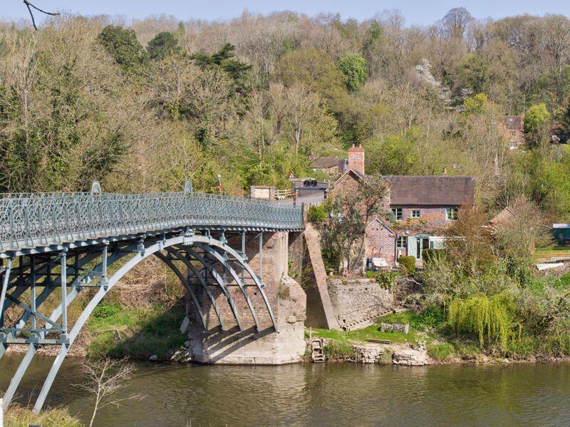
Iron arch and toll cottage are seen together from the Coalport bank in this present-day photograph. Framed like this, it becomes clear how deliberately bridge and gatehouse were designed to function as one — the cottage positioned precisely to let its keeper watch, and control, every crossing.Present dayThe best single view of how bridge and gatehouse were designed to work as one.

The Iron Bridge upstream was a wonder, but its tolls were heavy. Coalport, arriving later, undercut it. For a horse and cart, Coalport’s toll might only be a few pence.

For working people and hauliers, that difference mattered. By the late 19th century, Coalport Bridge was the more practical route, leaving the Iron Bridge increasingly a tourist landmark rather than a true workhorse.

A Scheduled Ancient Monument that still carries cars — rare anywhere in Britain.

Coalport Bridge today

Coalport’s two toll houses — one for the bridge, one for the road — remind us that until 1922, every journey here cost.

They were homes as well as workplaces, housing toll keepers, shoemakers, grocers, wheelwrights, and even a modeller in china. In living memory, one was still a shop where locals bought their Woodbines.

The bridge itself, first wooden and then rebuilt in iron, stands as a quieter cousin to the Iron Bridge but just as vital to the life of the Gorge. Today, with its weight limits and protections as both a Grade II listed building (toll house) and a Scheduled Ancient Monument (bridge), Coalport still tells the story of how the Severn was crossed, penny by penny, trade by trade.

Then & now

The same ground, a century apart

Drag each handle — or use the arrow keys — to fade between the old photograph and the view today.
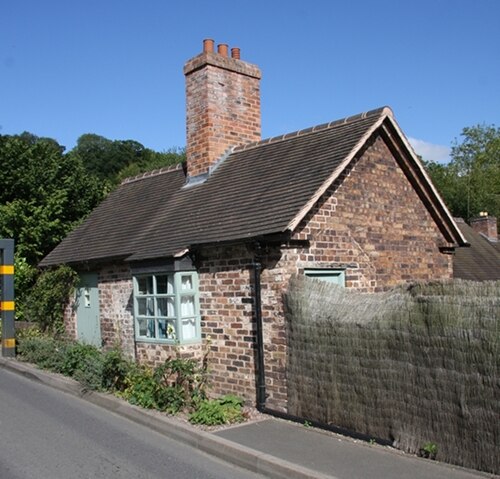
The restored brick toll cottage as it stands today, Grade II listed since 2002 after its 1990s rescue from dereliction. It's now a private home, so please enjoy the view and take your photographs from the road — the building's second life depends on the ongoing goodwill of the people who live there.
By 1964 the old toll house had become a village shop, Lyons' Tea and Park Drive cigarette signs crowding the window. Older residents still remember buying groceries and cigarettes through its stable-style door — a gentle reminder that this building's toll-collecting days were, by then, a fading local memory rather than lived experience.Then
Now
The same single-storey cottage: a village shop in 1964, and restored today
The green-painted span and its restored cottage, seen from the water in this recent photograph. It's easy to walk or drive past without registering the fact, but this is a Scheduled Ancient Monument still carrying everyday car traffic — a survival that is genuinely rare anywhere in Britain.
This hand-tinted postcard, W. S. Allcock's Post Card No. 15 from the early 1900s, gives the classic view of Coalport Bridge from the Shropshire bank. Look closely at the single cast-iron arch and the toll house at its northern end — the colourist's guesswork with the brickwork tones is part of what makes these cards such charming, if not always accurate, historical documents.Then
Now
The Edwardian postcard view, and the same span from the water now
The bridge toll house today, framed by a modern 3T weak-bridge sign standing in front of it. It's a striking single view: two centuries of traffic control captured together, the eighteenth-century gatehouse and the twenty-first-century height barrier both doing essentially the same job of managing who gets across.
A winter view past the toll house, mid-twentieth century, with 10 mph signs posted at each end of the deck. It's worth noting how early these restrictions began: speed and weight limits were already tightening decades before the heavy modern lorries that eventually forced far stricter controls on this fragile iron crossing.Then
Now
10 mph and a lorry on the deck, and today's 3-tonne weak-bridge signing
The signed approach today reads “only one vehicle on bridge”, backed up by height and width barriers across the road. Where a toll keeper once controlled traffic by hand and by conversation, these barriers now do the same job automatically, a quiet but telling shift in how the crossing is managed.
Titled “Coalport Bridge, Salop”, this early-1900s postcard shows the unmade approach road running alongside the river. Look at the rutted, rough surface underfoot — nothing like today's tarmac. It's a useful corrective to any romantic idea of Edwardian travel: reaching the bridge meant picking your way over industrial trackways, mud and all.Then
Now
The unmade approach road, and the barriered approach today
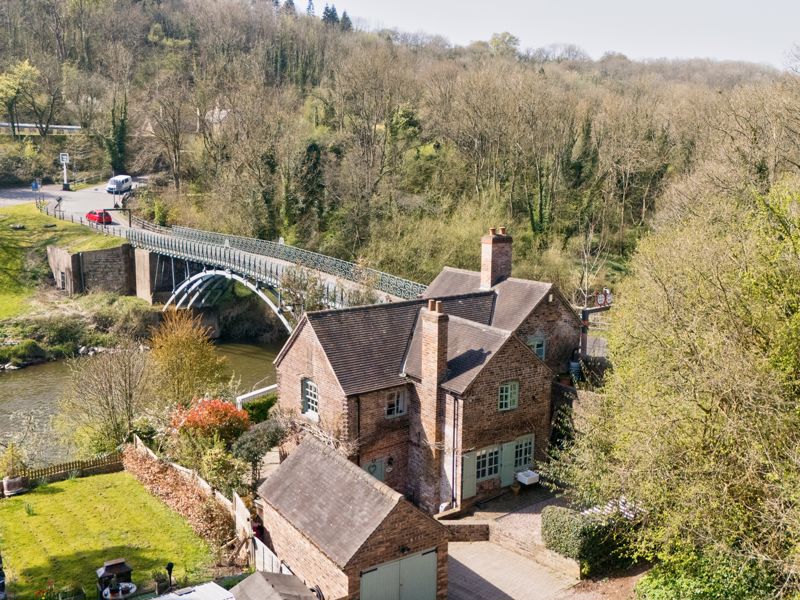
A drone view from April 2025 shows the toll cottage, the bridge and the wooded Gorge all at once, a perspective no historical photographer could have captured. It reveals the setting clearly: a crossing tucked tightly between steep wooded slopes, old riverside wharves and the winding Severn itself.
Motor cars cross in single file in this 1930s photograph, the village rising behind them up the valley side. By this decade the limits stood at 8 tons and 5 mph — modest figures today, but a sign that even early motor traffic was already asking more of this Georgian ironwork than it was built for.Then
Now
Cars crossing in the 1930s, and the crossing from the air in 2025
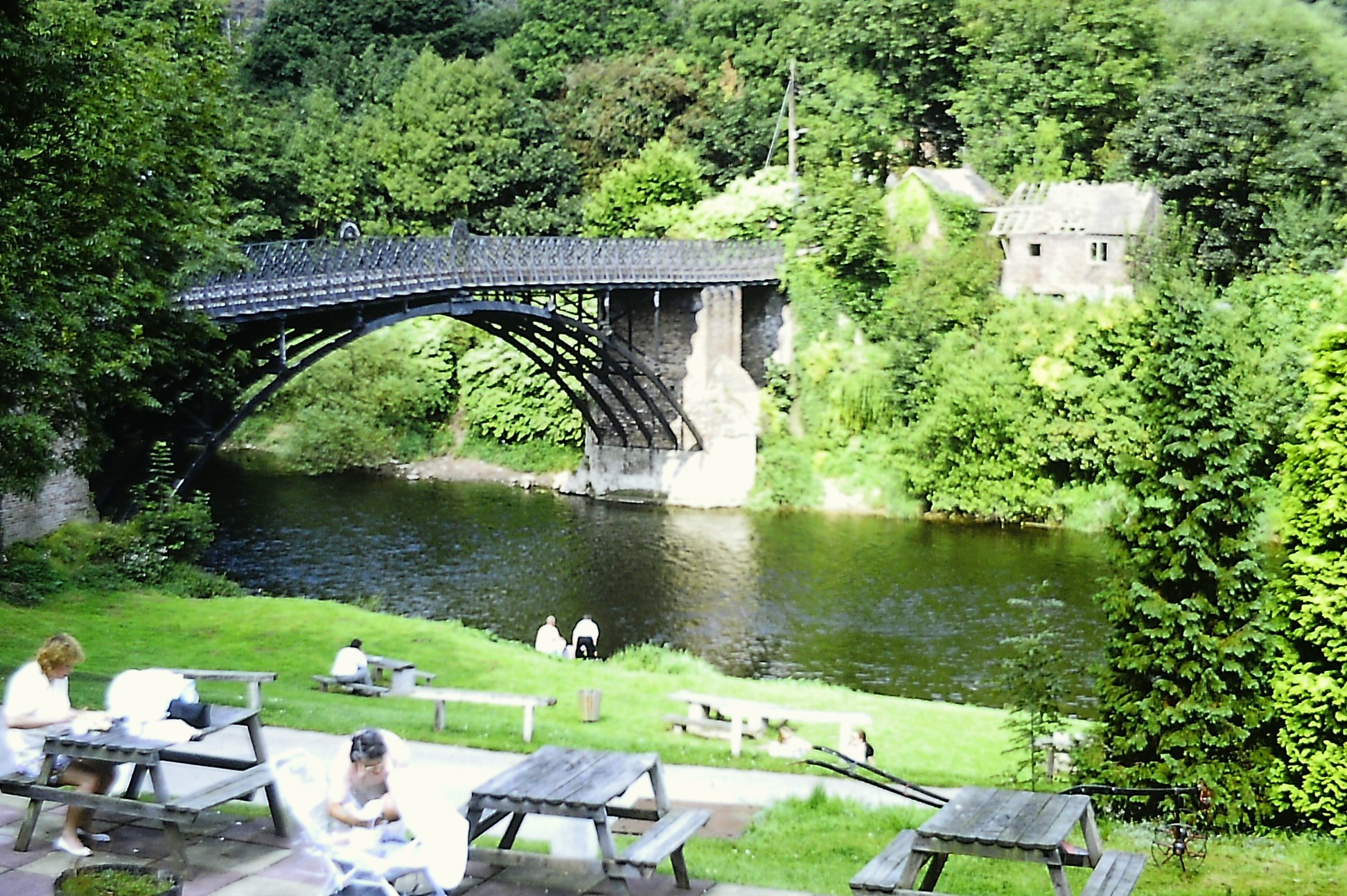
Picnic tables line the bank below the span today, walkers crossing the deck above, a scene of unhurried leisure that would have seemed odd to the tolls-paying traffic of earlier centuries. The Woodbridge Inn gardens beside the river remain the classic spot from which to view the arch in full.
A plain monochrome postcard, simply captioned “Coalport Bridge” and printed sometime in the early 1900s. Notice how the china works village climbs the hillside behind the deck — a reminder that this crossing existed to serve industry first, and travellers second, in the years when Coalport pottery was shipped downriver from here.Then
Now
The river view from the Coalport bank, then and now

On the ground

What you can still see today

The bridge toll house

At the north end of the deck. Warehouse from 1793, a house by 1815, then toll house and cottage after the 1818 rebuild. Restored 1994–96 and Grade II listed in 2002. Now a private home.

The “Old Toll House” (the catchgate)

A separate building up the approach road into Coalport, on the Madeley–Broseley–Coalport turnpike — not the cottage beside the bridge. Locals called it the catchgate because it caught you for a second toll straight after the bridge. Its spy holes survive; today it is a holiday let.

The Woodbridge Inn gardens

The classic viewpoint. Picnic tables on the bank give the full profile of the arch, with walkers crossing the deck above.

The Severn bank and flood line

Stand at the abutment and look for the flood debris line. The 1795 flood destroyed the timber bridge's middle pier and forced the rethink that produced the iron span.

All 44 photographs, sorted by theme. Tap any image to enlarge it.

Early 1900s
Early 1900s
Early 1900s
Early 1900s
Late 20th century
Late 20th century
Present day
Present day
Cast 1818

Take it with you

Spot it on the bridge

Tick these off as you walk the crossing and the approach roads. 0/8 found.

In closing

One of the finest surviving cast-iron road bridges in Britain

Coalport Bridge dates from 1818, when John Onions replaced a twice-beaten timber crossing of 1780 with a single cast-iron arch landed on the older brick abutments. Two centuries later it is still open, still carrying traffic, and still recognisably the bridge in the Edwardian postcards at the top of this page.

That combination — early cast iron, largely unaltered, and in continuous everyday use — makes it one of the finest surviving cast-iron road bridges in the country and a key structure within the Ironbridge Gorge World Heritage Site. It is a Scheduled Ancient Monument, protected alongside its more famous neighbour a mile and a half upstream.

The toll house beside it has a longer story again. It began as a late 18th-century warehouse on the Coalport wharves, became a dwelling, then the bridge toll house after the 1818 rebuild, later a village shop, then a near-ruin, and finally a restored, Grade II listed private home. Bridge and gatehouse have stood together through every one of those changes.

Plan your visit

Visiting Coalport Bridge today

Coalport Bridge remains one of the most picturesque crossings in the Ironbridge Gorge. Visitors can admire its remarkable cast iron structure, walk across the bridge and photograph the restored toll house beside it.

Nearby attractions include the Hay Inclined Plane, Coalport China Museum, the Tar Tunnel and riverside walks along the Severn Valley Way — with parking and refreshments at the Woodbridge Inn on the Coalport bank.

Have photographs of Coalport Bridge? Snapshots of the toll house, the gate, the shop or the floods would help grow this exhibition — send them to us on Facebook and we'll add them with a credit.

Keep exploring

Continue exploring the Gorge